School of Smart City, Chongqing Jiaotong University
日期:2024年12月07日
1.Introduction to School of Smart City
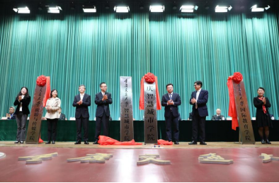
At the end of 2018,School of Smart City was established in response to the national call and the Chongqing Government's advocacy, to meet the talent needs of Chongqing's smart city construction and improve the level of urban intelligence and governance.In March 2022, the School of Smart City of Chongqing Jiaotong Universitywasofficially operated.
Oriented towards megacity governance, the School closely aligns with national and local strategic needs such as smart cities, a powerful transportation nation, and digital Chongqing, fostering interdisciplinary talents with a broad range of expertise who possess a solid foundation in surveying and mapping science, urban science, and data science, as well as strong technical and engineering practical abilities. Currently, the School has 53 faculty members, including 41 full-time teachers, 7 professors, 14 associate professors, 33 individuals with doctoral degrees, and 3 doctoral supervisors. It has flexibly recruited 1 national-level talent from the "New Century Hundred, Thousand, and Ten Thousand Talents Program". Additionally, there are 5 provincial and ministerial-level talents, including Chongqing Academic and Technical Leaders, Chongqing Outstanding Young Talents, and High-level Scientific and Technological Innovation Talents of the Ministry of Natural Resources, as well as 1 recipient of the Chongqing May 1st Labor Medal. The School boasts 3 master's degree authorization points in Surveying and Mapping Science and Technology (the only and key discipline in Chongqing), Resources and Environment (Surveying and Mapping Engineering), and Intelligent Surveying and Mapping and Spatio-temporal Information Engineering (not listed in the directory), as well as 2 undergraduate majors: Surveying and Mapping Engineering (a national-level first-class undergraduate major) and Geospatial Information Engineering (smart city orientation).
The School, based in Chongqing while facing the whole country, leverages its professional strengths in intelligent surveying and mapping, and spatio-temporal information, and integrates multiple disciplines such as civil engineering, transportation, urban planning, and information technology. It has established four key research directions: space-air-ground intelligent perception and digital twins, intelligent and numerical control of urban traffic and autonomous driving, monitoring and early warning of traffic infrastructure and geological disasters, and monitoring and early warning of urban land use and ecological security risks. The School adopts an integrated "industry-science-education" talent cultivation model, and its students have won over 100 awards in national, provincial, and municipal academic and professional competitions. It boasts two provincial and ministerial platforms: the Chongqing Key Laboratory of Spatio-Temporal Information for Mountainous Cities and the Engineering Technology Innovation Center for Spatio-Temporal Information and Equipment in Smart Cities of the Ministry of Natural Resources. In the past five years, the School has undertaken more than 10 national-level projects such as "Research on City Multi-view Semantic 3D Modeling Driven by Cross-modal Scene Information," and over 30 provincial and ministerial projects including "Research on Key Technologies for Early Warning of Structural Safety of Traffic Infrastructure in Mountainous Areas" and "Research on End-cloud Collaborative Service Technologies for Intelligent Driving on Complex Roads." With a total research funding of approximately RMB 30 million, it has received nearly 20 provincial and ministerial scientific and technological awards, such as the Chongqing Science and Technology Progress Award, published more than 500 academic papers, and released nearly 20 textbooks and academic monographs.
2.Leadership
(1)General Secretary of the Party:Rongbo He.

To preside over the overall work of the party branch of the school. Responsible for grass-roots party building, ideological and political education for faculty and staff,ideology, publicity, united front, security and stability,incorrupt politics construction, cadre assessment, news propaganda and other work.In charge of the School office, the School trade union, and the faculty congress. Contact the surveying and mapping laboratory, the geoinformation department.Manage and servetheparty branch of faculty and staff.
(2)Dean:Jian Chen

To preside over the overall administration of the School. Responsible for development planning,degree and discipline construction, specialty construction, scientific research,personnel talentteam construction, financialandasset management, post appointment and assessment, external cooperation and exchangeand other work. In charge of the disciplinary and postgraduate management office, the academic committee, theprofessorcommittee, the academic degree evaluation subcommittee, the professional title review committeeand the smart city research institute.Contact the faculty party branch of the geographic information and land resources department and surveying and mapping department.
(3)Secretary of Committee for Discipline Inspection: Xun Luo
Assist the General Secretary to improve the party affairs. Responsible for the development, education, management of party members, the construction of grass-roots party organization, discipline inspection and supervision and other work. In charge of the disciplinary committee and the Party School of the school.
(4)Vice Secretary of the Party:Zhen Liu

Assist the General Secretary to improve the party affairs. Responsible for students' ideological and political education and daily management, second classroom activities, party organization construction and management, recruitment and employment, study style construction, alumni liaison and other work. In charge of the student work office/youth league committeeof the school, and contact the undergraduate party branch.
Assist the dean in the work of discipline construction, scientific research, postgraduate training, and external cooperation and exchanges.
Hosting part of the responsibilities of thevice dean.Assist the dean in the administrative work of theschool.Responsible for teaching operation management, teaching team building, teaching monitoring, quality engineering construction, curriculum construction, teaching laboratory construction, education and teaching reform research, practical teaching management, practice base construction, student innovation and entrepreneurshipand other work. In charge of teaching management office, teaching steering committee and teaching experiment center of theschool. Contact the surveying and mapping department.
3.Introduction of Major
1)Geospatial Information Engineering
Major Introduction
Geospatial Information Engineering is a special major approved by the Ministry of Education in 2016 in response to the development trend of disciplines and national needs.The professional code is 081205T, andthe degree is awarded in engineering. This major intersects surveying and mapping science and technology, geographic science and computer science and integratessurveying and mapping technology, computer technology, network technology, sensor technology and mobile communication technology to solve engineering application problems, such as geospatial data collection, processing, analysis, visualization and service.
The major has a solid school foundation and strong faculty.There are more than 30 full-time teachers, including 6 high-level scientific and technological innovation talents from the Ministry of Natural Resources,Outstanding Young Talent of Chongqing and other provincial and ministerial talents, 8 professors, 10 associate professors, 3 doctoral supervisors, and 4 postdoctoral cooperative supervisors.Currently, the school has the only and key discipline of Surveying and Mapping in Chongqing:Surveying and Mapping Science and Technology, an Engineering Master degree program in Resources and Environment (Surveying and Mapping Engineering), an Academic master’s degree authorization site in Intelligent Surveying,Mapping and Spatio-temporal Information Engineering, and a smart city disciplinary groupin Chongqing.The science and education platform includes the Intelligent Urban Space-time Information and Equipment Engineering Technology Innovation Center of the Ministry of Natural Resources and Key Laboratory of Intelligent Surveying and Mapping of Chongqing.The total area of the teaching laboratory is more than 3,000 square meters, equipped with modern high-tech scientific research and teachingequipment such as deep learning workstations, photo grammetry workstations, 3D laser scanners, drone aerial photography systems, and the latest remote sensing and geographic information system software.Furthermore, we have maintained long-term industry-university-research strategic cooperation with many large-scale enterprises and institutions in the country and southwest region, including planning, natural resources, Internet, intelligent network connection, transportation, etc., and have achieved remarkable practical teaching results.
This major is the only one in the western region, and it will recruit 60-70 students nationwide starting in 2023.
Orientation
Facing the construction of a new type of smart city, Chengdu-Chongqing economic circle, andnational strategic needs of the Science City in Western China, the school aims to empower digital and intelligent transformation of urban governance and decision-making, and cultivatescross-type compound senior technical talents who have mastered the basic theories, technologies and engineering practice methods of geospatial information technology, urban science and data science.
Training objectives
Driven byspatio-temporal big data and intelligent innovation, through cross-integration of surveying and mapping, spatial information science, computer science and other disciplines, focusing on spatio-temporal data processing, analysis, modeling and application services,the school carries out system theory and engineering quality education and highlights the cultivation of practical innovation ability.
Remote sensing principles and image processing, principles and applications of spatial data bases, GIS engineering and development,urban spatial modeling and simulation,urban spatio-temporal big data technology,and intelligent information courses such as computer and the Internet, programming, computer application practice, scientific computing and data visualization.
Employment and Further Education
Graduates can engage in intelligent application research, technology development and production management of spatial information in the fields of smart city construction and operation, land and space planning and natural resources, intelligent transportation, public safety, ecological environment and Internet location services. They can also continue their studies in surveying and mapping, geography, computer science and other disciplines.
2)Surveying and Mapping Engineering
Major Introduction
The surveying and mapping engineering major originated from the Surveying Teaching and Research Group of Southwest Highway College in 1951, and began to recruit undergraduates in 2002.Now it is an ational first-class major, passed the national engineering education professional certification,and is also a first-class major in Chongqing,the professional strength is the first in Chongqing and the leading in the west.
At present, There are more than 30 full-time teachers, including 6 high-level scientific and technological innovation talents from the Ministry of Natural Resources,Outstanding Young Talent of Chongqing and other provincial and ministerial talents, 8 professors and 10 associate professor.The total area of the teaching laboratory is more than 3,000 square meters, equipped with modern high-tech scientific research and teaching equipment such as deep learning work stations, photogrammetry work stations, 3D laser scanners, drone aerial photography systems, and the latest remote sensing and geographic information system software. Furthermore,the school has signed practical teaching bases with many enterprises and institutions in the country and southwest region,involving surveying and mapping, natural resources, Internetand other fields, and has achieved remarkable practical teaching results.Every year, 120-140 students are recruited nationwide.
Orientation
This major is based on surveying and mapping, and is oriented to the needs of the smart city industry.Closely followingthe country's major strategies of "double carbon", Chengdu-Chongqing economic circle andnational strategic needs of the Science City in Western China,through strengthening the deep integration of teaching, learning, researchand application,the schoolactively carriesout the application practice of urban management, natural resources, transportation and civil engineering and other industries, in order to create a distinctive, domestic first-class new surveying and mappingandgeospatial information teaching and research highland, and cultivate high-level surveying and mapping and geospatial information application talents.
Training objectives
This major trains senior technicaltalentswithcomprehensivedevelopment of morality, intelligence, physical education, art and labor, and theoretical, technical and engineering practical capabilities in surveying and mapping science, urban science and data science.Graduates canmeet the needs of governments, enterprises and institutions related to smart citiessuch as digital twins, intelligent transportation, urban public safety, urban ecological environment, land resources, urban planning, Internet location services. Moreover, they canengage in surveying and mapping and geospatial information application research, technology development, production and management.
The main courses
Principles and applications of remote sensing, digital photogrammetry, principles and applications of global positioning systems, engineering surveying, principles and applications of geographic information systems.
Employment and Further Education
The annual employment rate is over 90%. Graduates are widely employed in enterprises and institutions related to smart cities, such as transportation, Internet, planning, natural resources and ecological environmental protection.Every year, dozens of graduates continue to study for master's degrees in "985" universities.
4.Academic staff
1)Xiaoyu Cai
Male, professor, doctor of Tongji University, doctoral supervisor,postdoctoral cooperative supervisor.Senior visiting scholar of Saitama Institute of Technology and Hong Kong Polytechnic University. The dean of theSchool of Smart City, Chongqing Jiaotong University, and the deputy director of the Chongqing Key Laboratory of Mountainous Urban Transportation System and Safety.Won Chongqing May 1st Labor Medal, Chongqing Youth May 4th Red Banner Bearer, and Outstanding Talent Program of Chongqing Universities. Member of the Transportation Planning Academic Committee of Urban Planning Society of China,member of the Smart City Working Committee of Chinese Society of Surveying and Mapping,deputydirector of the Chongqing New Smart City Construction Alliance Expert Committee, Deputy director of the Transportation Planning and TOD Planning Academic Committee of Chongqing Urban Planning Society,member of the Expert Working Committee of Intelligent Engineering Branch of Chongqing Construction Industry Association, member of the Technical Committee of Chongqing Urban Traffic Big Data Analysis and Application Engineering Technology Research Center, member of the Academic Committee of Chongqing Key Laboratory of Mountainous Urban Traffic System and Safety. Reviewer for academic journals such as IEEE, JAT, "China Highway Journal", "Highway Transportation Science and Technology", "Journal of Chongqing Jiaotong University (Natural Science Edition)". Long-term commitment to scientific and technological work in the field of mountain traffic management and transportation efficiency improvement.Significant advantages and characteristics have shown in five aspects: traffic big data and digital twins, traffic system operation and safety evaluation, congestion evolution mechanism and travel portraits, traffic monitoring and early warning collaborative control in hotspot areas of arterial routes, intelligent transportation system research and development and engineering design. For actual combat application scenarios, a complete set of key technologies and systems for traffic monitoring, early warning and control of long tunnels, traffic arteries, and hotspot areas have been developed. Presided over 4 projects in Chongqing, such as the key project of technological innovation and application demonstration, outstanding talent plan project for colleges and universities, and the science and technology project of Urban Traffic Big Data Engineering Technology Research Center. Moreover, mainly research 8 projects,such as national science and technology support plan project,Chongqing social undertakings and people's livelihood security special major projects/key projects, open projects of key laboratories of the Ministry of Public Security.Undertake more than 60 technical research and development consulting projects of local governments, enterprises and institutions. Won 11 provincial and ministerial science and technology awards, including Shanghai Science and Technology Award, China Highway Society Science and Technology Award, China Intelligent Transportation Association Science and Technology Award, Chongqing Social Development Award, Chongqing Excellent Urban Planning and Design Award, and Chongqing Excellent Engineering Consulting Award, Chongqing Construction Innovation Award, Sichuan Provincial Excellent Urban and Rural Planning Design Award, among which there are 7 projects as the first complete person. Published more than 70 academic papers, of which more than 20 papers were included in SCI/EI.Won 8 national invention patents, 2 patents for utility model, and more than 20 software copyrights. Guided students to participate in the National Transportation Science and Technology Competition and the Intelligent Transportation Innovation and Entrepreneurship Competition,and won the second prize at the national level twice.
2)Jianping Pan
Male, professor, doctor of State Key Laboratory of Surveying, Mapping and Remote Sensing Information Engineering of Wuhan University.High-level scientific and technological innovation talents of the Ministry of Natural Resources, former youth academic technology leader of the National Bureau of Surveying, Mapping and Geographic Information, expert of the expert database of the Ministry of Science and Technology (key research and development plan), evaluation expert of the National Natural Science Foundation of China, deputy director of the Engineering Surveying Branch of the Chinese Society of Surveying and Mapping,director of the Aerial Survey and Cartography Special Committee of the Chongqing Society of Surveying, Mapping and Geographic Information, and a member of the Traffic Big Data Spatial-Temporal Analysis and Application Technical Committee of the Interdisciplinary Department of the World Transportation Conference. Presided over and participated in more than 40 science and technology projects.Won the second prize of provincial and ministerial level twice and the third prize for 4 times.Published more than 90 academic papers, including 18 major indexed articles(SCI/EI/ISTP), and 3 edited books.Obtained 6 national invention patents, 1 patentofutility model and 4 software Copyrights.
3)Dongjie Guan
Female, professor, doctor of Kitakyushu City University in Japan,doctoral supervisor,visiting scholar of the Institute of Emergency and Disaster Reduction Management of Beijing Normal University.The teaching and research work mainly focuses on intelligent ecology and sustainable development, big data and cloud model construction, analysis of the evolution of ecological security patterns in the Three Gorges Reservoir, ecosystem service flow paths simulation and diffusion effectsassessment, simulation of land-use scenarios, and application of "3S" technology.Published 77 papers as the first author (or corresponding author), of which 29 were included in SCI/EI, and 2 monographs.Presided over 11 national and provincial projects, and won many awards, including the Young Teacher Award of the Huo Yingdong Education Foundation, the title of Young Backbone Teacher in Chongqing Universities, and the winner of Outstanding Youth in Chongqing. Lectures on "Big Data Visualization", "Principles and Applications of Geographic Information System", "ArcGIS Application and Practice", "Urban Ecology", "Frontiers of Geographic Information Science"and other courses. Supervised 1 doctoral student and 26 graduate students, many of whom won national scholarships, first-class scholarships, and titles of outstanding graduates, and 2 masters were studying for doctoral degrees overseas.
4)Guobing Pan
Male,professor,doctor.Mainly engaged in teaching and research in development of structural automation platforms and risk forecasting, UAV surveying and mapping, real-world 3D modeling and 3D laser scanning.Candidate for Chongqing Academic Technology Leader (Discipline of Surveying and Mapping Science and Technology), member of the Smart City Working Committee of the Chinese Society of Surveying and Mapping, and member of the Engineering Surveying Branch of the Chinese Society of Surveying and Mapping. Reviewer for academic journals such as "Tunnel Construction", "Journal of Underground Space and Engineering", "Journal of Chinese Safety Science", "Journal of Lighting Engineering", "Journal of Chongqing Jiaotong University (Natural Science Edition)". Undertook more than 10 national, provincial and ministerial-level scientific research projects, and more than 50 horizontal scientific research projects. In recent years,undertaken many projects,mainly includingthe Beibei District Museum Cultural Relics Digital Protection Project, Fuling Tongziyuan Landslide GNSS Automatic Emergency Monitoring, Zhengwan High-speed Railway Cow Herding Automatic monitoring of ground subsidence of Ping Tunnel, automatic monitoring of deck subsidence of upper-span cable-stayed bridge of Yuxiang Expressway, automatic monitoring of displacement and stress of operating tunnel of Line 5, automatic monitoring of GNSS of Xiangjiapo landslide group, automatic monitoring of high-fill embankment of high-speed railway,3Dscanning and modeling of operating tunnels, intelligent supervision of modern surveying and mapping benchmark (mine) infrastructure, research on second-class leveling methods for cross-sea leveling of Shenzhen-Zhongshan Channel, surveying of control network of Chengdu-Chongqing double-track expresswayand so on. Obtained 5 national invention patents, 3 software copyrights, 1 editor-in-chief textbook, 1 deputy editor-in-chief textbook, 3co-editortextbooks, and 2 provincial and ministerial achievement awards. Lecturer for undergraduate courses: "Deformation Monitoring and Data Processing", "Engineering Surveying", "Descriptive Geometry and Surveying and Mapping CAD", "Principles and Applications of Global Positioning System". Lecturer for postgraduate courses: "Deformation Monitoring", "Precision Engineering Measurement".Guided postgraduates to participate in the team's industry-university-research projects, so that the students' theoretical and practical abilities are simultaneously improved, and the students are highly valued byemployersafter graduation.
5)Fengyun Mou
Female,doctor,professor,mastersupervisor,postdoctoralcooperativesupervisor.Communication Evaluation Expert of National Natural Science Foundation of China,member of Expert Committee of China GIS Application Level Examination,member of Education and Science Popularization Committee of China Geographic Information Industry Association,member of Chinese Geographical Society, China Natural Science Foundation of China Member of the Resource Society, deputy director of the Education Professional Committee of the Chongqing Society of Surveying, Mapping and Geographic Information, supervisory director of the Chongqing Female Scientists and Technologists Association,vice chairman of Beidou Industry-Education Integration Innovation Professional Committee of China Satellite Navigation and Positioning Association, excellent instructor of National Undergraduate GIS Skills Competition. Top Ten Excellent Science and Technology Teachers of University Group of "Beidou Cup" National Youth Science and Technology Innovation Competition. Received the honorary titles of Outstanding Communist Party Members, Outstanding Party Affairs Workers andthe 4th Most PopularTop Ten TeachersofChongqing Jiaotong University.
Mainly carry out scientific research and teaching work on remote sensing of land and resources, intelligent perception of traffic spatio-temporal big data, resilient citiesandsmart disaster prevention and mitigationand so on.Presidedover more than 20 national, provincial and ministerial projects, and publishedmore than 100 papers.Won more than 50 awards, such as the second prize of the National GIS Teaching Achievement Award in Universities, the second prize of Transportation Education Science Outstanding Achievement Award of China Transportation Education Research Association, the third prize of Teaching Achievement Award of Chongqing Social Science Association, the Outstanding Achievement Award of Graduate Education and Teaching Reform ofChongqing Jiaotong University, the Special Award of Excellent Teacher Quality of Chongqing Jiaotong University, the Award of Excellence in Teaching Quality, and Excellent instructor of master's thesis and undergraduate thesis.Lectured on the school-level first-class courses "Cartography" and "Remote Sensing Geoscience Analysis", the school-level ideological and political demonstration course "Principles and Methods of 3S Technology Integration", the high-quality postgraduate course in Chongqing "Digital Hydrology and Digital Watershed" and other courses. Presided over 12 educational reform projects at the provincial and ministerial level and above, and compiled 5 monographs. Guided more than 20 postgraduate students, several of them obtained the title of outstanding master's degree thesis and outstanding graduates, and many of them studied for doctoral degrees.
6)Xiao Feng
Male, professor,doctor of Engineering of Southeast University,master supervisor,short-term visiting scholar of Louisiana State University, Imperial College of Technologyand Zurich Industrial School.Evaluation expert of the National Natural Science Foundation of China, evaluation expert of international cooperation projects of the Ministry of Science and Technology, member of the second committee of the Chongqing Science and Technology Association, and vice chairman of the second and third councils of the Chongqing Society of Surveying and Mapping. Served as the head of the first-level discipline of Surveying and Mapping Science and Technology in Chongqing Jiaotong University. Mainly carry out research and teaching work in the fields of intelligent survey, survey and design integration, digital ground model and intelligent GIS, structural detection and automatic monitoring. Published nearly 100 domestic and foreign papers, dozens of which have been included in major international search databases. Won 2 provincial and ministerial-level scientific and technological progress second prizes and 2 third prizes.Published more than ten national invention patents and a number of software copyrights.Lectures on"General Surveying", "Engineering Surveying", "Control Surveying", "Cadastral Surveying", "Introduction to Surveying and Mapping" and other major courses.Successively participated in the compilation of "Engineering Surveying" textbooks for the 11th Five-Year Plan, "Traffic Civil Engineering Surveying"and so on,and presided over the construction of "Engineering Surveying" high-quality courses. Guided more than 50 graduate students, many of whom entered 985/211 universities to study for doctoral degrees.
7)Chun Chen
Female, professor,doctoral/postdoctoral fellowfromPeking University,doctoral supervisor, visiting scholar at the School of Geography and Planning, Cardiff University, UK.Mainly engaged in the research of GIS and land resources development, spatio-temporal behavior and planning. Director of Ecological Habitat and Green Transportation Research Center of Chongqing Jiaotong University, member of the Academic Committee of Chongqing Jiaotong University, deputy secretary-general and executive director of the Chongqing Geography Society, member of the Watershed Space Planning Academic Committee of the Urban Planning Society of China, member of the Digital Twin and Future City Special Committee of the Chinese Urban Science Research Association, director of the Chongqing Urban Planning Society, director of the Chongqing Land Resources and Real Estate Society, member of the Academic Committee of Land and Space General Planning of Chongqing Urban Planning Society, a director of World Chinese Real Estate Research Association, and a director of China Construction Management and Real Estate Research Association. Presided over 3 national-level projects, including the National Natural Science Foundation of China and sub-projects of national key research and development projects, 4 provincial-level projects, including the Key Laboratory of the Ministry of Natural Resources, and Chongqing Science and Technology Bureau, and presided over a number of local horizontal projects in the field of land and resources. Lectured on "Urban Science", "Regional Analysis and Regional Planning" and other courses.Published a number of papers as the first author or corresponding author in academic journals such as Land Use Policy,Journal of Geographical Sciences,Urban Planning, Human Geography, Urban Development Studies, Urban Issues, Planner,and published 2 monographs by Science Press and Peking University Press.
8)Huarong Li
Female,doctor of Wuhan University, master tutor,visiting scholar of London South Bank University.Mainly engaged in the research ofgeospatial information visualization, indoor map expression, indoor positioning and navigation, UAV image data processingand so on, published more than 30 papers. Presided over and participated in more than 10 national, provincial and ministerial projects, and published 1 monograph.Wonthe title ofExcellentTeaching Quality Award and Outstanding Instructorfor many times. Lectures on "Engineering Surveying", "Surveying and Mapping CAD", "Cartography", "Principles and Applications of Geographic Information Systems" and other courses. Compiled the teaching materials of "Cartography", "Civil Engineering Surveying", "AutoCAD and Surveying and Mapping Application".Responsible for the construction of the first-class course "Principles and ApplicationsofGeographic Information System" in Chongqing. Guided students to participate in the National Undergraduate Surveying and Mapping Skills Competition, Surveying and Mapping Innovationand DevelopmentCompetition, Science and Technology Paper Competition for many times, won special prizesandfirst prizesand so on.
9)Yong He
Doctor of Engineering,associate professor,master tutor,director of the Department of Geographic Information and Land Resources, School of Smart City, Chongqing Jiaotong University.Member of the Chinese Geographical Society, member of the Education and Science Popularization Committee oftheChinaGIS Association, member of the Urban Planning and Construction Working Committee of the Sixth Chongqing Municipal Committee of the Peasants and Workers Party, member of the Chongqing Municipal Planning and Surveying and Mapping Science and Technology Committee, and deputy director of Surveying, Mapping and Geographic Information Education Committee. Main research fields: digital city, smart city, 3S technology of land and resources, transportationinformationization, remote sensing and geographic information system engineering. Presided over/researched more than 20 scientific research topics and horizontal projects, published more than 20 academic papers, and participated in the compilation and publication of 2 textbooks ("Principles and Methods of Geographic Information Systems", "Principles and Applications of Remote Sensing"). On-going researchprojects: National key research and development plan project, key special sub-topic of Internet of Things and Smart City "Urban Management and Service Technology of Physical-Digital Space Integration" (2019YFB2102503).
10)Zhixiang Cao
Male,master of Southwest Jiaotong University, master tutor,national registered surveying and mapping engineer.Participated in the construction of Guangxi South-North Expressway, the ramp project of Chongqing Huayuan Bridge, Binjiang Road on the South Bank of Chongqing, Yibin Nanxi Yangtze River Bridge, and Hong Kong-Zhuhai-Macao Cross-sea Bridge. Lectures on "Engineering Survey", "Survey Adjustment", "Principles and ApplicationsofDigital Mapping", "Global Satellite Positioning System" and other courses. Among them, the "Engineering Survey" course was rated as a key course in Chongqing, an excellent course in Chongqing and an excellent resource sharing course in Chongqing. Publicly published textbooks such as "Survey of Traffic Civil Engineering", "Surveying", "Large Scale Digital Mapping Technology", "Professional Knowledge of Surveyors". One of the main reviewers of the latest national standards "Engineering Surveying Standards" and "Engineering Surveying Operation Procedures". Published more than 20 papers.
11)Feifei Tang
Female,associate professor,master supervisor,doctorfrom Wuhan University,post-doctor jointly trained by Chongqing University and Chongqing SurveyInstitute, visiting scholar at the University of Twente’s Faculty of Geo-Information Science and Earth Observation(ITC), Netherlands, online review expert of National Natural Science Foundation of China, Chongqing Expert of Municipal Planning and Natural Resources Bureau, member of Chinese Society of Rock Mechanics and Engineering.Mainly engaged in the research ofthe interdisciplinary research and application of unmanned aerial vehicles, 3D laser scanning, spatio-temporal geographic information technology in the fields of transportation infrastructure construction and operation and maintenance, natural resources and geological disaster monitoring andearly warning. Published more than 30 academic papers,includingmore than 10 SCI and EI papers, 3 invention patents, 3 software copyrights. Presided over and mainly researched more than 20 national/provincial and ministerial-level projects such as national key research and development projects and the National Natural Science Foundation of China. Won the first prize of the Science and Technology Award of China Communications and Transportation Association, the second prize of the Science and Technology Award of China Highway Society, the third prize of the Science and Technology Award of China Highway Society, the second prize of the Science and Technology Progress Award of ChinaSociety of Rock Mechanics and Engineering, the third prize of the Non-metal Mining Science and Technology Award of China Non-Metal Mining Industry Association and the third prize of the Science and Technology Award of Zhongguancun Green Mine Industry Alliance. Lectures on "Engineering Surveying", "Computer Graphics", "UAV Low-altitude Remote Sensing Technology"and other courses. Guided more than 20 graduate students, many of whom entered high-tech enterprises, well-known enterprises and institutions, and one of them entered the University of Stuttgart in Germany to study for a doctorate.
12)Jinhong Xu
Male, Ph.D., associate professor, master tutor, national registered surveying and mapping engineer.Member of the National Surveying and Mapping Professional Teaching Steering Committee,deputy Director of Chongqing Surveying, Mapping and Geographic Information Association.Mainly engaged in the research of engineering surveying, remote sensing and geographic information system, global positioning system and other aspects. Presided over and participated in more than 20 national, provincial and ministerial horizontal scientific research projects.Published more than 20 papers, and participated in the compilation of 5 textbooks. Won the second prize in the National Surveying and Mapping Young Teacher Lecture Competition, the second prize in the school-level lecture competition, 9excellentteaching quality awards,the title of"Excellent Graduation Thesis Instructor", "Science and Education Innovation Classroom Teaching First Prize", "Excellent Communist Party Member ", "Advanced Individual in Teaching Work", "Excellent Teaching Achievement Award at the School Level"and so on. Lectured on "Basics of Geodesy", "Engineering Surveying", "General Surveying" and other courses. Guided students to participate in competitions and won more than 10 national, provincial and ministerial awards.
13)Bo Peng
Male, Han nationality,born in April 1986, associate professor,doctor of engineering, visiting scholar of Oklahoma State University in the United States. Mainly engaged inthe research oftraffic flow analysis, traffic video/image automatic recognition.Published more than 30 papers in coreand abovejournals and international academic conferences,such asChina Highway Journal, Southeast University Journal, Southwest Jiaotong University Journal, Highway Traffic Science and Technology, ASCE Annual Meeting. Presided over 1 National Natural Science Foundation of China Youth Science Fund, 5 provincial and ministerial level scientific research projects, 1 provincial and ministerial level higher education reform key project. Mainly research 2 National Natural Science Foundation of China Youth Science Fund, 2 provincial and ministerial level major special sub-projects.Wonthethird prize of Science and Technology Award of Intelligent Transportation Association. Recent research focuses on the extraction and analysis of traffic parameters based on UAV video, traffic state recognition and evolution mechanism. Lectures on "Urban Planning Principles", "Rail Transit Operation Organization", "Urban and Rural Roads and Traffic Planning", "Transportation Science and Technology Paper Writing", "Traffic Transportation Engineering Frontier Lectures", "Introduction to Transportation Majors", "Parking Planning and management".
14)Na Lin
Female, associate professor, postdoctor/doctor, master supervisor, secretary of the teaching and labor party branch of the Department of Surveying and Mapping, visiting scholar at Ryerson University in Canada.Mainly engaged in teaching and scientific researchofremote sensing image intelligent processing, hyperspectral remote sensing, application of INSAR geological disaster monitoring, engineering surveyingand so on. Published more than 30 academic papers, won 3 software copyrights, presided over and participated in 12 national and provincial projects, won1second prize of Chongqing Science and Technology Progress Award, 2 teaching reform achievement awards, andthe title ofoutstanding party workerofthe school. Lectures on "Principles and ApplicationsofRemote Sensing", "Advanced Remote Sensing Technology", "Engineering Surveying", "Digital Photogrammetry", "Remote Sensing Digital Image Processing", "Traffic Geographic Information System"and other courses, among which "Principles and ApplicationsofRemote Sensing" is school-levelfirst-classcourse. Guided 17 graduate students, many of whom won the first prize, second-class scholarship, and the title of outstanding graduate.
15)Guodong Liu
Male, associate professor, master student of Taiyuan University of Technology, master tutor.Mainly engaged in teaching and scientific researchofgeographic information technology, remote sensing application, surveying and mapping engineering, 3S technology application in transportation and environmentand so on. Published more than 30 academic papers, of which 6 wereincludedinSCl and EI. Presided over and participated in more than 10 national and provincial scientific research projects. Lectures on "General Surveying", "Basics of Geodesy", "Engineering Surveying", "Basics of Error Theory and Survey Adjustment", "Geographic Information System Theory and Advanced Applications", "WebGIS Principles and Development", "GIS Spatial Analysis", "Python Artificial Intelligence Application" and other courses. Edited the textbooks "AutoCAD and Surveying and Mapping Applications", "GPS Principles and Applications", and participated in the construction of excellent courses "Geographic Information System Principles and Applications" and "Engineering Surveying". Guided more than 20 postgraduate students, many of them won scholarships of various levels and related honorary titles, and entered the government and land related departmentsafter graduation.
16)Maolin Chen
Male, associate professor, master tutor.Received a bachelor's degree in remote sensing science and technology, a master's degree in surveying and mapping engineering, and a doctorate in photogrammetry and remote sensing from Wuhan Universityin 2012, 2014, 2018, respectively.The deputy director of the Institute of Advanced Surveying and Mapping of Mountain Bridges and Tunnels, Chongqing Jiaotong University,andselected into the "Youth Top Talent Support Program" ("Hundred Talents Program") of Chongqing Jiaotong University. Mainly engaged in teaching and research related to engineering survey and spatial database, and scientific research on 3D laser scanning data processing. Published more than 20 SCI/EI papers, obtained 6 patents and software copyrights. Presided over or participated in 6 national, provincial and ministerial projectssuch asthe National Natural Science Foundation of China and the Natural Science Foundation of Chongqing. Reviewer for many international journals such as "Remote Sensing", "IEEE JSTARS", "Sensors", "Applied Science", "Measurement", and the chairman of the IGARSS 2020 session. Guided 5 postgraduate students, published 8 papers including Chinese core, CSCD journal papers and EI conference papers, andapproved for 3 graduate innovation projects (2 at the municipal level). Guided 3 innovation and entrepreneurship projects forundergraduatestudents (including 1 at the municipal level and 1 project for excellent completion),1 academic project for college students in the national youth and youth work research projectand so on. Won4 awards for "Internet +" college students' innovation and entrepreneurship projects. Supervised undergraduate students to publish 3 academic papers, wonthenational Group Special Prize in Surveying and Mapping Skills Contest,and the secondprize in National Undergraduate Science and Technology Paper Competition.
17)Chuan Hu
Male, associate professor, doctor, national registered surveying and mapping engineer, mainly engaged in teaching and scientific research of measurement data processing and engineering application. Lecturer for undergraduate courses: "Basics of Surveying Adjustment" and "Engineering Surveying".
18)Kangwen Zhu
Male,Ph.D., associate professor, mastertutorof Southwest University, expert of Chongqing Environmental Science and Technology Expert Database, member of Chongqing Environmental Science Society, the first youth editorial board member of "Journal of Ecology and Rural Environment", guest editor of "Remote Sensing" journal, "Land" " Reviewer for periodicals such as Three Gorges Ecological Environment Monitoring and Environmental Impact Assessment.Mainly engaged in ecological planning and restoration, ecological function and value assessment, non-point source pollution control and other related researches. Won 5 awardssuch asthe third prize of Chongqing Development Research Award and local awards. Presided over/researched more than 20 projects including National Natural Science Foundation of China, Chongqing Municipal Natural Science Foundation, Chongqing Municipal Key R&D Projects, Chongqing Municipal Key Projects, Chongqing Municipal Performance Guidance Special Projects, and Chongqing Municipal General Scientific Research Projects. Published 45 papers in "Global Ecology and Conservation", "Chinese Geographical Science", "Land", "Scientific Reports", "Journal of Agricultural Engineering", "Environmental Science Research" and other journals,of which 31 were published as thefirst/corresponding authors (7 SCI, 2 EI), obtained 3 software copyrights, presided over/participated in the compilation of 5 Chongqing local standards, group standards, and technical guidelines, and applied for 5 patents.